El Niño and La Niña are two different phases of the warming and cooling of the Pacific Ocean. This pendulum swing between temperatures has polazrizing effects on surf zones across the globe, depending on which phase the ocean is in.
El Niño is when a pool of warm water heats up in the Pacific Ocean, and La Niña is when the ocean is notably cooler than the average temperature. This is called the ENSO cycle (El-Niño Southern Oscillation) and is a climate phenomenon specifically in the Pacific Ocean. But what do both phases of the cycle actually mean?
What Is The ENSO Cycle?
The ENSO cycle is a shifting, sliding scale of water temperature in the Pacific Ocean that heavily dictates weather patters across the globe.
The ENSO cycle lasts roughly two-to-seven years, shifting the sea surface temperatures and atmospheric air pressure in the Pacific.
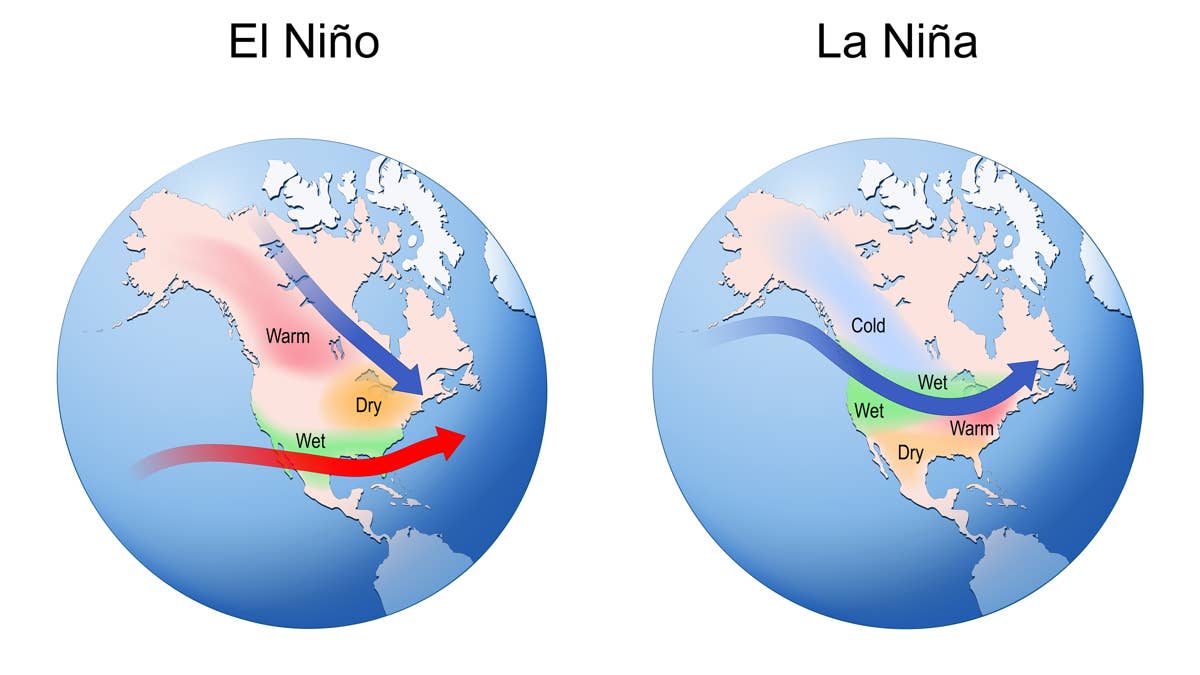
There are three phases; El Niño, where the ocean water temperatures are significantly warmer than average. La Niña, where the water temperatures are colder than the average. And ENSO neutral, a normal period where the water temperature is close to the average.
The impacts of the ENSO cycle are felt far behind the push and pull of decent surf. This climate driver can impact agriculture across the globe, fishing and seasonal weather events.
Related: Guide To The World’s Biggest Waves
What Does El Niño Mean For Surfing?
This really depends where you are in the world. In the northern hemisphere, especially on the Pacific side, El Niño is typically associated with more frequent and powerful storms.
This means bigger surf for California, more consistent swells in Hawaii and generally, stronger North Pacific storm activity. This could also mean more rainfall this year and wildly inconsistent conditions in other regions.
It was 10-years-ago, in 2016, when the last strong El Niño formed up. This year, it looks as if there will be another strong climate event, setting off multiple surf zones across the Pacific and having an impact into Europe too. Typicaly, El Niño in the Old Continent means worse waves and wind.
What Is La Niña?
During La Niña events the trade winds in the Pacific Ocean strengthen. These winds push warm water towards the western fringe of the Pacific and allows for colder water to rise in the eastern Pacific – which means atmospheric circulation goes around the other way.
So what does this mean? La Niña actually creates more stable weather patterns globally. For surfing, it can have a significant impact on wave quality and have the opposite impact than El Niño.
For instance, in California, La Niña can mean less winter swells compared to El Niño years – but it might produce cleaner conditions, depending on where you are. On the other hand, La Niña helps create a more active Atlantic Hurricane season, meaning more swells for the Caribbean and East Coast and over into Europe too. Those Atlantic hurricanes can be so powerful, they spin up the right coast, re-intensify near Newfoundland and boost swell over to Ireland, the UK, France, Portugal and beyond.
For Australia, La Niña typically means there will be wetter conditions across the country and into south east Asia. But parts of Australia and Indonesia become glorious for surf under a La Niña, thanks to more storm activity and favorable wind patterns. However, it’s also never that straight forward.
Which One Is Better For Surfing?
That ultimately depends where you are in the world.
California: El Niño will be the one to look out for. A strong El Niño means more powerful storms, which means bigger and more consistent swells out of the North Pacific. But as we know, big storms do not always make the best conditions. With a strong El Nino, there’s the added risk of bad wind and unruly oceans. It’s just the likelihood of a more powerful winter is higher than La Niña or ENSO-neutral. On the other hand, La Niña winters can have smaller, cleaner conditions – but are often colder with less swell production.
Hawaii: El Niño often charges up Hawaii, thanks to the active North Pacific storm track. The North Shore of Oahu could see some incredibly special days when all the elements align and it’s not too unruly. Much like California, La Niña may see cleaner, smaller conditions but way less frequent.
Australia: La Niña can produce more storms along the east coast, with cyclone activity increasing – meaning long runs of warm waves. El Niño very often brings much drier conditions and a reduction in tropical activity.
Indonesia: El Niño means dry weather and light winds for surfing’s favorite archipelago. Those world-class waves begin to fire up with long runs of amazing surf. La Niña brings a lot more rain with it and some scattered wind.
Scientists Are Still Studying ENSO-Cycle
Some climate scientists are still studying how climate changes impact the ENSO-cycle. The common working theory is many believe these events could become more intense in the future, with larger swings between surf seasons. It could mean bigger storms in summer and some funky swell patterns that cuts against the grain of decades’ worth of forecast data. It’s understood to be a ways off yet, but we’re already seeing some changes in the weather patterns.
However, it is not yet clear of the fluctuating nature as of yet – once there is more data around this latest El Niño, due to form this year, there should be better metrics to understand the ENSO-cycle as a whole and how recent climate events have impacted the great Pacific warming and cooling.