Hurricane Polo has become one of those storms that meteorologists are running out of adjectives for. Terms like “jaw-dropping” and “astonishing” and “absolute insanity.”
After erupting from a tropical storm into a Category 5 hurricane, Polo weakened to Category 4 during an eyewall replacement cycle, then surged back to Category 5 before dipping again.
NASA says Polo’s peak winds reached roughly 180 mph, making it the third-strongest eastern Pacific hurricane on record by maximum sustained winds. Some analysts also believe it became the fastest storm on record in the basin to go from tropical depression to Category 5.
NASA atmospheric scientist Gary Partyka called Polo’s strengthening “explosively rapid intensification,” saying conditions around the storm were “near perfect”: weak wind shear, high moisture, extreme atmospheric instability and ocean temperatures approaching 90 degrees Fahrenheit. Polo gained about 104 mph in wind speed within 24 hours. The normally restrained National Hurricane Center called the intensification “truly remarkable.”
Related: Hurricane Polo Is So Powerful People Are Asking About ‘Category 6’ (Video)
Then there’s the ominously nicknamed “death band.”
Hurricane #Polo has developed a “death band” on its western side. Normally these bands are very dangerous to those in its path. Fortunately, it is currently over the water and is actually helping to take some of the fuel away from the #hurricane! https://t.co/tqzjDEeeft pic.twitter.com/x1eXunfGsC
— Hurricane Chaser Chase (@hurricane_chase) September 24, 2026
That is not an official meteorological term. Weather watchers have used it to describe an unusually pronounced spiral band extending from Polo’s western side. In meteorological terms, it’s essentially an intense outer rainband or feeder band — capable of producing torrential rain, violent wind gusts, and rough seas far from the eye. NHC satellite analysis confirmed a broad band of strong convection extending well away from Polo’s core.
Polo has already lashed southwestern Mexico with heavy rain, tropical-storm-force winds and dangerous surf. Ports were closed, classes suspended and coastal residents stacked sandbags as authorities warned of flash flooding and mudslides.
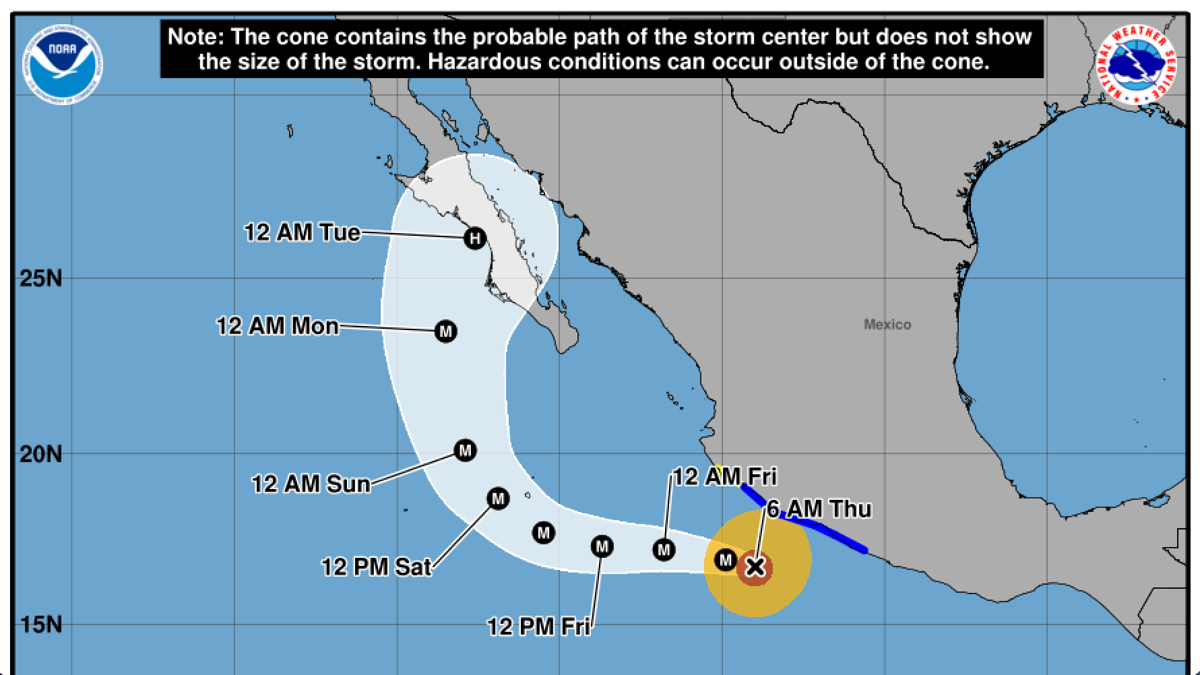
The storm is now pulling away from mainland Mexico. Forecasters expect it to track west, then west-northwest before potentially curving northeast toward Baja California next week. NASA says Polo should remain over the Pacific until then.
And even if the eye never comes ashore, the ocean may do the damage instead.
At last report, peak seas near Polo were running around 41 feet.
Stay tuned in the next coming days for what Polo will bring in terms of surf.
Related: Category 5 Hurricane Polo Explodes Into One of the Strongest Pacific Storms Ever