Hurricane Rachel spent days doing what most Eastern Pacific hurricanes do: spinning safely westward into the open ocean.
Now, it’s turning around.
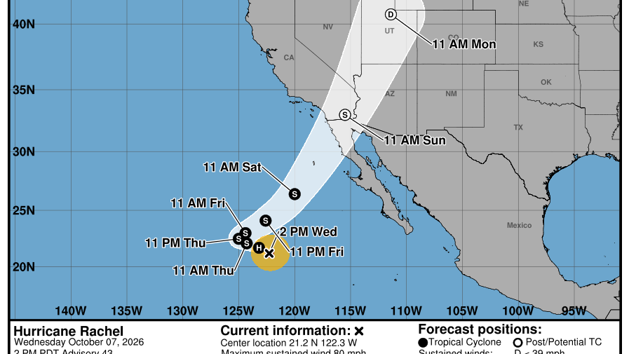
The National Hurricane Center says Rachel will slow before making a “sharp turn to the northeast” by the end of the week, accelerating back toward Baja California and Southern California. As of Wednesday afternoon, Rachel remained a Category 1 hurricane with 80-mph sustained winds roughly 800 miles west of southern Baja. Peak seas surrounding the storm were running around 35 feet.
The projected turn is highly unusual—though not unprecedented. Eastern Pacific hurricanes are normally steered westward away from California. This time, an approaching upper-level trough is expected to essentially grab Rachel and pull it northeast.
“Rachel is expected to slow down and then turn toward the northeast,” the NHC said, before accelerating toward Baja and Southern California. Forecasters stressed that there remains considerable uncertainty once the turn begins.
Rachel should weaken over cooler water and could be post-tropical before reaching land, potentially somewhere in northern Baja or near the U.S.-Mexico border Sunday. Still, its moisture, winds and ocean energy could have significant consequences.
Southern California is already feeling the ocean effects.
Related: Watch: 25-Foot Waves from Hurricane Rachel Slam Cabo’s Iconic Surf Spots
National Weather Service forecasters expect 3-to-6-foot surf across Orange and San Diego counties, dangerous rip currents and coastal flooding around 6.5-to-7-foot tides. By Sunday, Los Angeles-area forecasters say tides could reach approximately 7.5 feet, with vulnerable beaches facing “considerable to significant impacts.”
At Huntington Beach Wednesday, waves were already running roughly 4 to 6 feet.
“If you’re a beginner…it’s not a good idea to go out there right now,” one surfer told KTLA. “Very hazardous, breaking really hard on the sand, lots of rip, lots of undercurrents.”
Then there’s rain.
The NWS currently projects around half an inch for Los Angeles and Ventura counties, while eastern L.A. County mountains could receive up to 2 inches. Thunderstorms are also possible.
The NHC warns Rachel’s swells will continue building along Southern California through the weekend, producing “life-threatening surf and rip current conditions.”
California has seen tropical systems approach before—most recently Hilary in 2023—but a forecast cone extending toward Southern California remains an extraordinary sight.
Rachel may not arrive as a hurricane.
But after spending days heading harmlessly out to sea, the fact that it’s coming back is worth watching very closely.
Related: 1,000-Mile Kelvin Wave Touches Down in SoCal. Here’s What to Expect