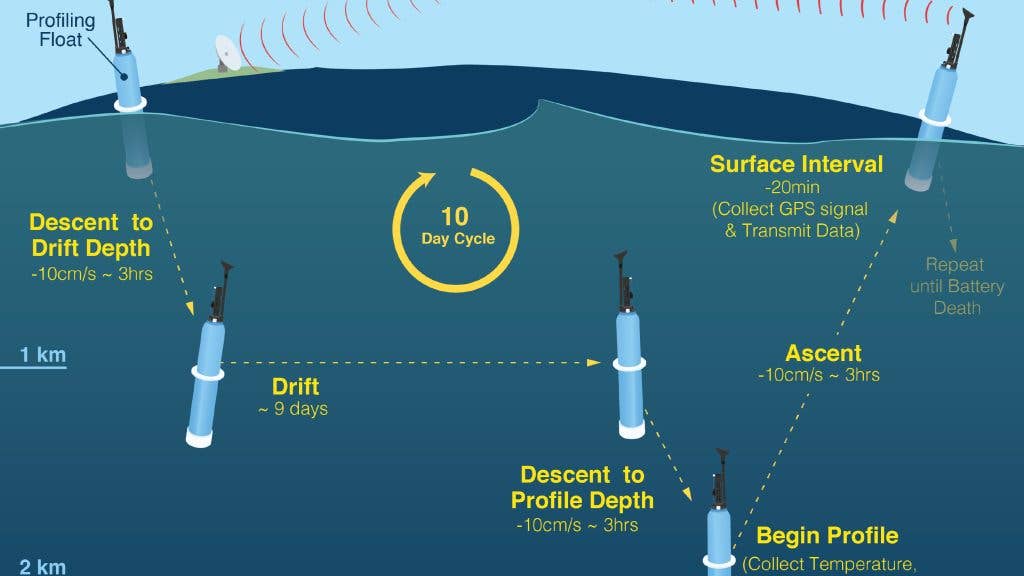
Autonomous robots called Biogeochemical-ARGO floats measure and monitor the world’s oceans’ acidification levels, temperature fluxes, and ecosystem statuses by collecting mile-deep acidity, oxygen, temperature, and chlorophyll data and transmitting it to Scripps Institute researchers via satellite, though perhaps not for long, thanks to federal funding cuts.
“It has the biology, the geology, chemistry kind of wrapped up into one thing. And that’s what these floats are, kind of aim to do,” UC San Diego Scripps Institution of Oceanography engineer and scientist Tyler Wirth told San Diego’s KPBS.
The National Oceanic and Atmospheric Administration had unofficially agreed to support the ongoing project, currently in its 16th year , but federal funding for the program is set to cease in October as part of larger 2025 budget cuts to NOAA.
“It’s sad,” Wirth lamented. “I spent a career, my Ph.D., working on this project.”
Woods Hole Oceanographic Institution (WHOI) participated in the ARGO program from the get-go. WHOI Senior Scientist Susan Wijffels told KPBS that “It’s revolutionary that we can sit in our office and get an oxygen profile or get a nitrate profile from the middle of the Southern Ocean in winter.”
And lest you think this has nothing to do with surfing interests, it’s all somehow connected: Quicker snapshots of nitrate levels mean sooner alerts to harmful algal blooms (HABs)—you know, the stuff that leads to life- and limb-threatening infections collected in the lineup.
To that end, whether you give a damn or not about what might be happening in the Southern Ocean midwinter, it pays to be informed. Losing cutting-edge gear like this might not seem like much, but keeping data is how we keep politics from mucking and miring our science (and politics) in the first place.
Furthermore, these Biogeochemical (BGC) floats—of which there are currently about 500—are simple to run: “They’re just buoyancy driven. So, it just has an external balloon that inflates and deflates and allows it to go up and down,” Scripps Oceanographer Sarah Purkey explained to KPBS. “It has a little bit of electronics and then it has a bunch of D-cell batteries.” The floats have a lifespan of five years, can venture down more than a mile, and surface every 10 days to transmit data from their antennae at the surface.
The U.S. Navy, as well as weather forecasters and research centers also use this data in various capacities.
Right now, it’s helping scientists at Scripps study the current super El Niño—another thing that has heavy bearing on what happens in and to the surf.
“If we take away that network,” says Purkey, “If we don’t maintain it, you don’t only lose the science, but you lose your ability to see what’s coming.”
Eighteen countries currently contribute to this global network of BGC bots, and while the U.S. deploys about half of them, Scripps estimates that to continue the program, it would cost taxpayers a whopping 10 cents a year, and sense of security aside, what else can you buy for that?